![[Lower Edmonton]](../images-odds/header-left.jpg)
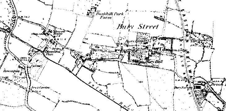
If you look on old maps of the area I call Lower Edmonton (such as the 1867 one, extract shown above) you will notice that Bury Street is a separately identified and isolated hamlet grouped around what is now the junction of Bury Street and Bury Street West with the A10 Great Cambridge Road and with some activity around Little Bury Street. So I thought it would be good to acknowledge this with a dedicated page even if I can't say too much about it.
It does, however, give me a place holder for any discussion I might want to make of the part of the N9 postal area between Church Street, Bury Street West and the A10 which I call Lower Edmonton but which is some ways feels more like Winchmore Hill or Bush Hill Park to the north and south. It is generally treated as part of "Edmonton" even if it is arguably not really either Upper or Lower!
Even today development in this area largely confined to the main roads themselves, and between Little Bury Street and the A10, and indeed on the other side of the A10 too, there is a lot of open space in the form of school grounds, playing fields, parks and allotments.
I have added Bush Hill Park to the title of this page because I want to acknowledge that, even after the divide with Southgate, large chunks of what we now call Bush Hill Park were part of Edmonton and I assume they remained part of the municpal borough until the 1960s. However when talking about "Edmonton" these days this area does not tend to feature and it certainly has an identity of its own.
![[image]](../images/digital/2003/01/08/100-1432.jpg)
![[image]](../images/digital/2003/01/08/100-1428.jpg)
![[image]](../images/digital/2003/01/09/100-1451.jpg)
![[image]](../images/digital/2003/01/08/100-1427.jpg)
Although the Bury Street West area is really the part I was intending to focus on (the "West" bit is a 20th Century addition to the name), it would be a little silly not to start with Bury Street the road as that is probably what people think of first. If I hadn't cropped the 1867 map for this page, you would see Brook House, Millbridge Farm and Millbrook House mentioned but ,apart from suggesting that their names reflect the presence of Saddlers Mill Stream which now runs culverted just north of Croyland Road, I don't have anything much to say about them. Indeed apart from St Michaels church at the eastern end (on the churches page) there isn't really too much of note until the junction with Galliard Road and Croyland Road. The 1894 maps show Millbrook Road and Findon Road developed on the east side and development to the north in the South Road and Sutherland Road areas. However apart from one terrace on the north side just west of Crescent Road and a few bits and bobs at the east end, Bury Street itself is pretty clear. I suspect however that the 1894 map merely caught the start of the development as the style of housing down the road is all pretty consistent and matches that elsewhere that is already on the map. The photos above are taken west of Millbrook Road to hint at the mish-mash of stuff still down that end, from just west of Kenwood Road to show the typical housing, of the terrace leading to Crescent Road that was on the 1894 map (this terrace does seem a bit different to any others I noticed) and finally looking back across Croyland Road.
![[image]](../images/digital/2003/01/08/100-1430.jpg)
![[image]](../images/digital/2003/01/08/100-1434.jpg)
![[image]](../images/digital/2003/01/08/100-1431.jpg)
The photos above show a terrace that is typical of the road and this one is on the north side just east of the Kenwood Road junction. Most terraces are like this with just a few only having the bay on the ground floor and the two or three that seem unique but still of the same broad style. The middle photo is not meant to be arty, I just wanted to try and sneak a closer photo of the house (number 53) for a previous resident who is now in the U.S. and that is what came out. As luck would have it, number 53 is one of the minority of the houses that hasn't been pebbledsahed and so show the original brickwork. Notice also how the roofs above the bay are not the same on every house.
![[image]](../images/digital/2003/02/10/100-1469.jpg)
![[image]](../images/digital/2002/07/28/100-0806.jpg)
![[image]](../images/digital/2003/03/03/100-1562.jpg)
![[image]](../images/digital/2002/09/25/100-1104.jpg)
The Newbury Unit (left and centre ) is on the south side of the junction with Galliard Road and Croyland Road but don't know much about the history of the building. The building has the look of a school about it and I feel sure there was an article about it in the local papers a good few years back for some reason. A contributor to the message board familiar with the building post-war suggests it was called Bassishaw Hall and was owned by St Michael's church who used it for Sunday school and has their church hall (replacing Maton Hall) until they built a new church hall in the 1960s and sold this building to the council.
On the Galliard Road side there is the off-licence (right) in a building that seems to bear no relation to any others in the area.
![[image]](../images/digital/2003/01/08/100-1435.jpg)
![[image]](../images/digital/2002/09/18/100-1004.jpg)
The road then goes up over the railway bridge (there was originally a level crossing) which now has some houses shoehorned in on the south side (left) where there were just some garages and waste land, and on the north side has a residential home (right) and one end of a whole new estate built on the waste land between the back gardens of St Edmunds Road and the railway line (it is possible there may have been some allotments here once but I'm not sure). Examination of the 1894 map strongly suggests that the first bit of Croyland Road was the old line of Bury Street which led to the level crossing and continued as what is now the end of Chichester Road outside the pub.
![[image]](../images/digital/2004/01/27/P1001998.jpg)
![[image]](../images/digital/2003/03/03/100-1563.jpg)
![[image]](../images/digital/2002/07/28/100-0802.jpg)
The road then swings right past Walmer House (above centre and right) which has its own mini multi-storey car park by the side (left). It has been tarted up a bit in recent years and looks all the better for it. Next to the car park is a brick built electricity sub-station.
![[image]](../images/digital/2004/01/27/P1002001.jpg)
![[image]](../images/digital/2004/01/27/P1001999.jpg)
Next to Walmer House, and just before the road swings west to head towards the Great Cambridge Road, there is a terrace of houses (above right) that can be dated to 1899 (the date is clearly visible on them). The houses opposite, and on both sides of the rest of this stretch of road feature a variety of different styles of what appear to be 1920s or 1930s period housing. Immediately opposite the terrace above the houses show some of the neo-tudor stylings that were apparently quite fashionable between the wars. Closest to the junction there is a heavier triangular styling on the terraces (above left) which I suspect might date them more to the 1920s as the older parts of Galliard Road and the first parts of the Hyde Estate seem show similar styling.
This area is the first of the more historically interesting parts...

![[image]](../images/scans/postcards/el/068.jpg)
One significant building from Bury Street of old was Bury Hall (shown left in a 1798 sketch) which was a timber framed Tudor mansion and in the 18th Century the home of the Galliard family. It was demolished in 1920 unfortunately. Tranmere Road and Darley Road are sitting on the approximate location now. The photo on the right dates from around 1900 and shows the 19th Century frontage, but the source calls it Jacobean (OK so that follows Tudor so its close enough agreement) but confuses the location with that of Bury House (below).
Bury Hall seems to nestle nicely in the strange north / west / south alignment of Bury Street and Bury Street West around what is now the A10 junction that interrupts an otherwise east-west route. I think the road was like that before the house was built and there has been speculation that the lost route of Ermine Street through Edmonton could have something to do with it.
As an aside, Ermine Street's route is lost between Tottenham High Road to the south and Lincoln Road to the north. I had been wondering about an alignment taking in the old footbridge at the end of Church Lane (leading to Marlborough Road) but looking at maps it is clear that this footpath originally ran directly from the bridge in a north-westerly direction to meet what is now Bury Street West at the point where it swings to the west. Another more significant footpath led from Church Lane in a slight curve towards a footbridge over Salmon's Brook roughly where Latymer Road is now, which then lead directly in a northerly direction to pick up Bury Street where it swings north. This seems to have more potential as a strong north-south route just seems to stop.
There are suggestions that Ermine Street must have run somewhere near where Victoria Road is now and it has even been suggested that a slight ridge along the edge of Pymmes Park could indicate the line of the road. It has also been suggested that it ran somewhere near the Latymer Road side of Churchfields and an archaeologist did once claim to have picked it up in the playing fields between Delhi Road and the Great Cambridge Road but it seems he didn't leave supporting evidence for this claim. On the other hand a couple of documents about Roman Enfield project a line of Ermine Street that runs further to the east, including passing close to the west side of Jubilee Park and crossing Bury Street nearer the other side of the railway bridge. So perhaps I am not being at all absurd in thinking this footpath might be significant.
![[image]](../images/scans/ioee/p36t.jpg)
![[image]](../images/scans/postcards/cahodge/277.jpg)
![[image]](../images/digital/2002/07/28/100-0796.jpg)
![[image]](../images/digital/2002/07/28/100-0797.jpg)
Another significant building was Bury House (shown left in 1904) which was located where Cambridge Terrace is now. It was used by the Nurses' Institute from 1900 to the late 1920s (the second photo is from a postcard used in 1924). I don't know if the building had any great age. I've added a couple of modern views of the site.
![[image]](../images/digital/2002/07/28/100-0793.jpg)
![[image]](../images/digital/2002/07/28/100-0795.jpg)
![[image]](../images/digital/2002/07/28/100-0791.jpg)
![[image]](../images/digital/2002/07/28/100-0794.jpg)
Bury Street West as seen today is largely a product of the 1920s onwards and was previously more of a country lane. There were a number of large country houses there and Salisbury House is the sole survivor. It is actually the oldest building in Edmonton apart from All Saint's Church and dates from the late 16th / early 17th Century with some 18th and 19th Century features. To me it was always the somewhat out of place building standing alone just before Bury Lodge Park with a featureless wall at street level. I guess I was always on that side of the street when I passed it and/or maybe the gardens were overgrown because it doesn't trigger any memories.
Eccleston suggests that the property might have belonged to a yeoman or a minor gentleman which would be consistent with the size (it isn't very big as old country houses go) though it is also thought that it might have been part of a much larger building. The name might come from the Marquess Of Salisbury's family or from a corruption of the Sayesbury estate. The house had been both private residence and school before it was bought by Edmonton Council in 1936. The intention was to turn it into a museum but this never happened and it got seriously neglected. Escaping demolition, it was turned into an arts centre in the 1950s. In 1992 it underwent a major restoration lasting a year and using ancient materials and techniques. It has also had a 17th Century fireplace that was sold to a museum in 1907 reinstalled. It is listed Grade II* along with some of the surrounding garden walls.
![[image]](../images/scans/leip/33.jpg)
![[image]](../images/digital/2002/07/28/100-0779.jpg)
![[image]](../images/scans/azep/005.jpg)
![[image]](../images/digital/2002/07/28/100-0781.jpg)
Bury Street possessed a very old country pub in the Stag And Hounds dating back until at least the mid-18th Century and it is still there occupying a 1925 building (centre left in 2002) just to the left of the site of the old one (c. 1910 left) and more or less opposite the junction with Little Bury Street.
Its near neighbour the Beehive only seems to become established in the mid 19th Century so is a mere youngster in comparison and its lesser status is clear as it is not marked on the 1881 map as the Stag and Hounds is. The current building opened in 1936 (right in 2002). Previously it traded from the end two of a row of five cottages (centre right) just to the north on the junction that were lost to road widening and realignment back in the 1930s. I think they ran along Little Bury Street rather than along Bury Street West and this is consistent with a glimpse in a photo below.
![[image]](../images/digital/2002/07/28/100-0784.jpg)
![[image]](../images/digital/2002/07/28/100-0783.jpg)
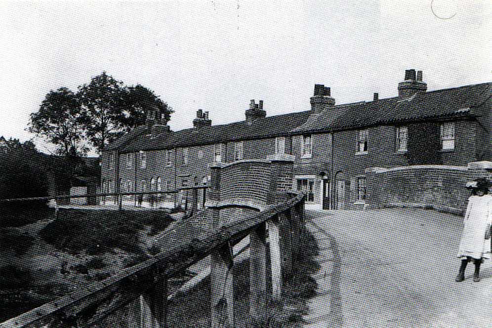
Above left is "Montefiore Place, Little Bury Street" in 1900 with the bridge over Salmon's Brook in the foreground. These 18th Century cottages lasted until the 1930s before being replaced by modern housing. Montefiore's Place is clearly marked on the 1881 OS Map (on the east side of the road just north of the brook) but now you will find Ramscroft Close opening on to Little Bury Street here. The gables of the Beehive pub can be seen in the left background showing how the original pub was slightly further away. This leads me to speculate it has been relocated. Just to put the photo in context if you turn to the right you would see Edmonton County Lower School (right). When I went there "County" wasn't back in the name and it opened as Rowantree Secondary Modern before merging with Edmonton County Grammar to become a comprehensive.
Edmonton County Lower School is now the Bury Campus of Edmonton County School. The school operates as two parallel sites now and there is also a Primary School on the Bury Campus.
If you look at the 1881 map you will notice after Bury Street (West) joins with Church Street the road continues in a vaguely north-westerly direction. This is now called Bush Hill Road and it leads up to meet Bush Hill which was the original main road to Enfield. You may also notice that there basically isn't anything much where the area we call Bush Hill Park is today. I suspect Bush Hill formed the western boundary of Edmonton post 1881 and the northern boundary ran north of what is now Park Avenue and the railway station. This area, although very much having its own identity in modern times, is generally treated as Edmonton in historical books and since we can only really relate to Upper Edmonton and Lower Edmonton as areas it may be treated as Lower Edmonton. To put it another way if Graham Dalling includes it in Lower Edmonton In Pictures who am I to argue!
![[image]](../images/scans/leip/36.jpg)
![[image]](../images/scans/saep/023.jpg)
There were a number of country houses on Bush Hill and a couple are of particular note.
Bush Hill House (c. 1900 above left) was between Bush Hill and Bush Hill Road on the south-east side of the junction. It was built in the early 17th Century for Sir Hugh Myddleton. It was later updated and recased in brick and between 1850 and 1860 was leased to Sir Samuel Cunard, founder of the famous shipping line. In the 20th Century it was well known locally as Halliwick, a residential school for disabled children (it actually opened in 1911 as the Halliwick School For Crippled Girls). According to Eccleston, the house was altered quite considerably over the years to suit the purposes of the school so when they finished with it in the early 1990s there wasn't really anything worth keeping and the eventual demolition in 1993 wasn't a great surprise.
The largest mansion was between Bush Hill and Park Avenue where Ringmer Place is now and was called Bush Hill Park (!). This had a very large estate and much of this land was sold off in 1875 to developers who started building the area of suburban estates that took its name. Latterly known as Clock House, it survived until 1927.
I don't wish to consider Bush Hill Park any further on this site as although it was built on land that could historically be considered to be associated with Lower Edmonton, once the development started I consider it gained an identity of its own.