![[Lower Edmonton]](../../images-odds/header-left.jpg)
Salmon's Brook (with or without the apostrophe) runs roughly west to east through Lower Edmonton and can be seen from many vantage points even if there isn't always a right of way running alongside it (although for much of the course there is). I've tried to take a few photos to illustrate many of the vantage points but really most of them are pretty hopeless and pointless because they lack contrast and depth.
The brook rises on "Enfield Chase", which in this case means in the general vicinity of Hadley Wood. It runs east and then turns south under Hadley Road picking up the watercourses in Trent Park en route, and then it flows south-easterly through World's End and Grange Park to enter old Edmonton at Bush Hill where it runs under the New River.
![[image]](../../images/scans/toe/p119b.jpg)
![[image]](../../images/digital/2002/10/17/100-1330.jpg)
![[image]](../../images/digital/2002/10/17/100-1329.jpg)
Although slightly out of modern Lower Edmonton, this area is of interest for the Clarendon Arch and Tunnel. The Clarendon Arch forms the north-west entrance to the Tunnel which dates to around 1680 and is a brick built culvert carrying the brook (centre) under the New River and was apparently constructed for reinforcing purposes. Originally the New River was carried by the Bush Hill frame, a 666 feet long lead lined wooden aqueduct, but this remarkable piece of engineering for its day was replaced by a clay embankment in the 1780s and this fact is commemorated by an engraved stone (right) which can be seen above the arch.
Dalling suggests that the arch and tunnel is now used as a flood relief channel for the brook which might explain why the brook lots a bit puny. However if that is the case where the heck is the brook itself?
![[image]](../../images/digital/2002/10/17/100-1324.jpg)
![[image]](../../images/digital/2002/10/03/100-1197.jpg)
![[image]](../../images/digital/2004/10/26/P1002377.jpg)
The brook continues south-easterly entering a culvert some distance before it flows under Ridge Avenue where the bridge sides are still very much in place (photo left) and enters Lower Edmonton just south of Ridge Avenue clinic and library. On the west side of Church Street there is a bridge rampart but the brook is still culverted under a driveway but it emerges into the open on the east side (centre). The brook looks reasonably attractive from the bridge but the side of the culvert can look less so (photo right).
![[image]](../../images/scans/postcards/egordonsmith/392.jpg)
![[image]](../../images/scans/leip/04.jpg)
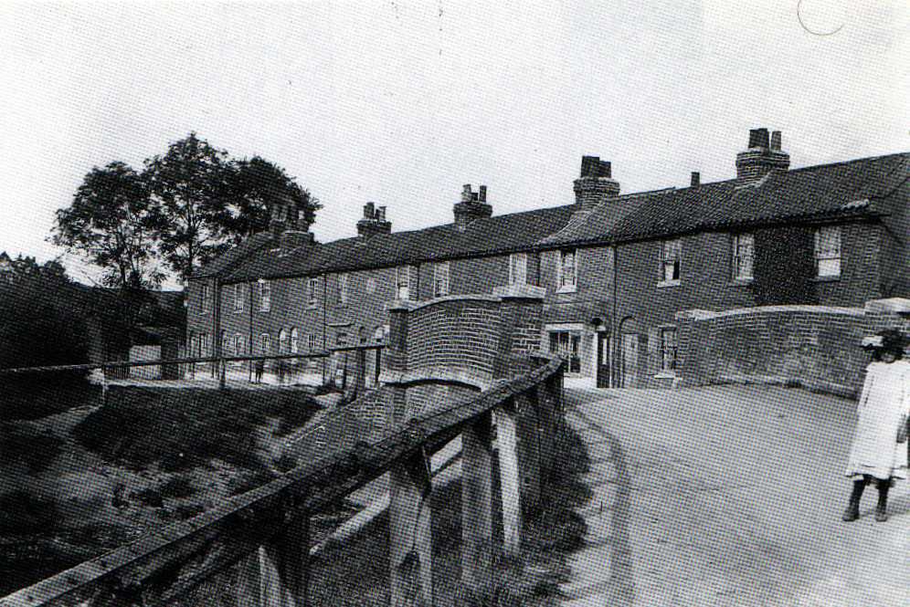
The existing bridge must be on the site of, or very near to, that of the long lost County Bridge which features in old postcards and afforded a somewhat different view to that there is today. My suspicion is that both the pictures, which would be c.1910 I should think, are showing the scene to the west of the bridge as late C19 O.S. maps show Church Street lined with trees on that side but open on the east. I may be wrong though and there is a possible hint of shadow on one to contradict me.
The subject of County Bridge came up on Facebook in April 2016. A couple of photos taken c. 1927 claim to show County Bridge in a state of extreme disrepair or demolition. However one shows housing and what appears to be a smaller footbridge in the background which could be interpreted as placing the bridge somewhere around about the location of modern Latymer Road. Old OS Maps suggest there may have been a footbridge in this location but don't show any paths or roads leading to it, and nor do any earlier maps hint at anything of significance there. The lost route of Ermine Street couldn't have been far away though.
The bridge in the photos seems to be a small single arch bridge which is inconsistent with the three arch bridge that features in the postcards. Just to add to the confusion various historical records talk of a three arch brick built bridge on the 'Lower Edmonton to Enfield' road which is generally called 'Salmon's Brook Bridge' and a two arch bridge named 'Lower Edmonton Bridge' which sounds like it was by the pond at Edmonton Green and they don't mention any other crossings (presumably the records predate the bridge on Little Bury Street shown in the photo below).
It does seem likely that the bridge in the postcard is 'Salmon's Brook Bridge' and it is in the assumed location.
![[image]](../../images/digital/2002/10/03/100-1196.jpg)
![[image]](../../images/digital/2002/10/03/100-1195.jpg)
![[image]](../../images/digital/2002/07/28/100-0784.jpg)
The brook continues east to run under Little Bury Street (photos left) on the north side of the school and although more hemmed in than it once was it is still clearly visible through the railings on the bridge that replaced a previous more substantial structure (photos right).
![[image]](../../images/digital/2002/10/17/100-1331.jpg)
![[image]](../../images/digital/2002/10/17/100-1332.jpg)
![[image]](../../images/digital/2002/10/17/100-1333.jpg)
The brook then runs between Bury Lodge Park and the school field (right to left) and then the council properties (the former plant nurseries) and some allotments to the Great Cambridge Road.
![[image]](../../images/digital/2002/10/03/100-1193.jpg)
![[image]](../../images/digital/2003/02/12/100-1489.jpg)
As it approaches the A10 Great Cambridge Road on the west side the brook runs under a small footbridge. The green fencing on the right hand side in the right hand photo surrounds a depot full of the big bin things you get at the recycling points. It is nice to compare the scene in October and February. The brook is culverted under the road in two channels. I don't know if that is to assist maintenance or for strength.
![[image]](../../images/digital/2002/10/03/100-1190.jpg)
![[image]](../../images/digital/2002/10/03/100-1189.jpg)
![[image]](../../images/digital/2002/10/12/100-1261.jpg)
On the east side (left and centre ) the brook then runs through some allotments and then to the south of Churchfield School's grounds where it goes into a culvert (right) and under Latymer Road. There seems to be a public right of way along the side of the brook for this distance.
![[image]](../../images/digital/2002/10/12/100-1260.jpg)
![[image]](../../images/digital/2002/10/12/100-1259.jpg)
![[image]](../../images/digital/2002/10/12/100-1258.jpg)
![[image]](../../images/digital/2002/10/12/100-1257.jpg)
The brook runs east from Latymer Road (left) between Marlborough Road and St Joan's Road. This is a prime dumping place for things like shopping trolleys though my favourite sight was a padded armchair beautifully positioned upright in the middle of the brook facing upstream.
Just past a closed public footpath (the bridge has been removed) the brook swings south (centre left) for about eighty yards or so under another bridge leading to the flats at the end of Church Lane (centre right) before swinging east again and immediately going into a culvert (right).
![[image]](../../images/digital/2002/10/09/100-1229.jpg)
![[image]](../../images/digital/2003/01/02/100-1419.jpg)
![[image]](../../images/digital/2003/06/27/DCP_1813.jpg)
![[image]](../../images/digital/2003/07/04/DCP_1814.jpg)
The course is clearly marked by a wide public footpath covering it that is now closed at one end but runs between Winchester and Chicester Roads (photos left) where it can usually be relied upon for an interesting collection of dumped stuff. Just to prove I didn't make that up, on the above right are glimpses into the culvert from Winchester Road in June/July 2003. The road sign warning of road closures talked of sixteen weeks of work but it was over by the end of July so lasted more like four or five.
![[image]](../../images/digital/2002/10/07/100-1203.jpg)
![[image]](../../images/digital/2002/10/07/100-1204.jpg)
The culverted brook continues from Chichester Road towards the railway (left) before it emerges and runs through the arches of the railway bridge (right). Some of the manhole covers in this path are dated as 1915 which might perhaps reflect a construction date for the culvert.
![[image]](../../images/digital/2003/12/15/P1001970.jpg)
![[image]](../../images/digital/2002/10/12/100-1255.jpg)
![[image]](../../images/digital/2002/10/12/100-1253.jpg)
Beyond the railway the brook runs east a short way and then turns parallel to Balham Road for what must be about 250 yards or so (photo left) before running under under Lacey Close and doglegging (photos centre and right) slightly to the south.
![[image]](../../images/digital/2002/10/12/100-1254.jpg)
![[image]](../../images/digital/2002/10/12/100-1252.jpg)
![[image]](../../images/digital/2004/03/31/P1002101.jpg)
The brook then heads to a culvert under The Green. It once opened out to form a pond in the middle of The Green. Eccleston talks of works to contain it when the railway opened in 1849 that were not successful as there continued to be problems including flooding. He says in 1883 concrete embankments were installed and the pond filled in and the area surrounded by railings. However this can't be the whole story. His description would cover the 'triangle' on the north side of The Green but a late 1880s photo shows the brook widening out slightly as it passes the Cross Keys and the 1894 map seems to suggest it was still there on the south side of the railway line (though I don't find it easy to interpret).
![[image]](../../images/digital/2002/09/26/100-1161.jpg)
![[image]](../../images/digital/2002/10/07/100-1213.jpg)
![[image]](../../images/digital/2002/10/19/100-1342.jpg)
Exactly where the brook runs underneath The Green I look at below but it emerges on the far side of Plevna Road next to the footpath built over the old railway line. Here the culvert has ceramic artwork on either side designed in association with two local primary schools. It is a nice idea but the culvert is so ugly and dirty that it seems slightly pointless. The original artwork from 2002 is called "Flow" and a couple of other pieces were added in 2003 (after the above photos were taken) called "Splash".
![[image]](../../images/digital/2003/01/22/100-1459.jpg)
![[image]](../../images/digital/2004/02/25/P1002050.jpg)
![[image]](../../images/digital/2002/10/19/100-1344.jpg)
![[image]](../../images/digital/2004/02/25/P1002051.jpg)
There is a footpath on the north side of the brook here that is part of the Pymmes Brook Trail and leads to Montagu Road opposite the recreation ground. The Plevna Road end has some rather nice gates and just inside the gates is an information board that I didn't stop to read. I don't know when it appeared but I wouldn't put it past them to have stuck it there just before the Queen was shown the area. The Pymmes Brook Trail signs further down the path are looking very tired now (I know you can't read the text on the photo but you struggle to read it on the actual thing!).
I have a suspicion that they used to have these boards at either end as well as in the middle but perhaps they removed them to make it look tidier. It is a pity the same attention isn't paid to the brook. The footpath is reasonably tidy but the south bank is badly littered and the brook also suffers as can be seen from a photo of one of five dumped bed mattresses I spotted in a brief walk around town in February 2004.
![[image]](../../images/digital/2002/09/26/100-1157.jpg)
![[image]](../../images/digital/2002/10/07/100-1217.jpg)
![[image]](../../images/digital/2002/10/07/100-1216.jpg)
![[image]](../../images/digital/2002/10/07/100-1214.jpg)
The brook and path are bordered on the north by the new housing, allotments and then the flats on Barrowfield Close, and on the south by the walled Jewish cemetery and then Tottenham Park cemetery.
The photos are arranged with the upstream viewpoint on the right. From the right they show the new housing bordering the path, then look past the allotments off camera to the left towards the Barrowfield Close flats, look back upstream hinting at the allotments on the right and then straight along the footpath with Barrowfield Close on the right.
![[image]](../../images/digital/2002/09/26/100-1154.jpg)
![[image]](../../images/digital/2002/09/26/100-1156.jpg)
![[image]](../../images/digital/2004/02/25/P1002053.jpg)
![[image]](../../images/digital/2004/02/25/P1002052.jpg)
As the brook approaches the culvert under Montagu Road (above) I noticed the flow stopped which seemed a little odd. The brook is taken about twenty or thirty yards north while in the culvert. Saddlers Mill Stream used to join the brook in the culvert and this made the area prone to flooding so the latter has been diverted to join in the open.
There are now gates on the Montagu Road end matching those on the Plevna Road end of the path, and plaques at both ends explain how they came about.
![[image]](../../images/digital/2003/02/20/100-1545.jpg)
![[image]](../../images/digital/2004/02/09/P1002025.jpg)
![[image]](../../images/digital/2004/05/11/P1002179.jpg)
The brook emerges in some waste land (or some welcome wilder open space if you prefer!) between the recreation ground and the new housing developments and from the road the only indication it is there is a line of higher trees and shrubs standing out from their surroundings. Actually that isn't quite true, passing it in February 2003 I could just about see water and it may just show in the photo (left) and in February 2004 there was a clearer view to the railings where it emerges (centre). In mid-May 2004 the view was even clearer as the culvert had been exposed and I am wondering if it has also been truncated a little. Maybe not.
I don't have any first hand knowledge from this point onwards but the maps indicate that the brook continues east well beyond Meridian way and then turns south parallel to the River Lee Navigation. It leaves Lower Edmonton and joins Pymmes Brook just south of the North Circular Road before the merged streams run south to join the River Lee around Ferry Lane (Tottenham Hale).
![[image]](../../images/scans/postcards/el/063.jpg)
Returning to the subject of the course under The Green, I have been looking at the 1867 and 1894 O.S. maps more closely and realising what had been staring me in the face. The maps indicate that the brook ran south along the east side of what became The Broadway. It then turned east to run just south of Knight's Lane and follow today's course. I had been thinking that a potential diagonal course under The Green was a little odd given the massive developments above it but had overlooked the obvious. It would explain why The Broadway was so broad for starters! The photo on the left shows a 1909 view with Salmon's Brook clearly in the open though it isn't visible in photos of the New Road junction dated 1910 so that could be when it was covered over.
Having just walked in this area I realised that a course south of Knight's Lane would take the brook straight under the swimming pool and certainly a picture above does show the brook emerging from that direction though it could change direction once underground. I don't think Knight's Lane has moved much so either it does indeed go under the pool or they have moved the brook!
Since writing the above I have seen it confirmed that the brook does indeed go under the leisure centre and that there are plans to divert it behind the police station when the leisure centre is replaced by a superstore (to be occupied by Asda). This was once talked of for 2004/5 but is more likely to be 2007 at earliest. Presumably this will all be underground which is a bit of a shame.
Something else I hadn't realised, and what led me to piece this together, was that somewhere under the site of the old Town Hall a second stream splits off from the brook to run south beyond Osman Road and then dogleg away to the south-east. There are modern roads called Brookfield Road, Brookside Road, and Brook Crescent near its course. This stream turned south to run along the west side of Montagu Road and join Pymmes Brook. On the 1801 enclosure map there is also a suggestion of a stream joining this just where it turns away from the line of the high road and I wonder if this might explain the curious alignment of the south end of Shrubbery Road.
Lesley Anderson, of the Montagu Road Flood Action Group, has kindly confirmed my assumption that this branch of Salmon's Brook still exists in a culvert though it now operates as an overflow system which channels water away from the main course at The Green when the brook is running high. This channel no longer feeds directly into Pymmes Brook as it once did as this historically caused flooding across and on both sides of the North Circular Road. Instead it has been diverted into the Intercepting Drain which carries it under the railway line to feed into Pymmes Brook further downstream. The culvert runs under the Police Station at The Green and was grated over when it was built, presumably for security reasons (Lesley reported that neither the Council or the Environment Agency claims to have been the body responsible for this, so who authorised and carried out this work is a bit of a mystery).
![[image]](../../images/digital/2004/05/11/P1002182.jpg)
![[image]](../../images/contrib/tsplymouth/rail2.jpg)
![[image]](../../images/contrib/tsplymouth/rail3.jpg)
I don't know much about the Intercepting Drain though I have seen a monitoring station mentioned with a grid reference placing it on the east side of the railway near Salmons Brook and I've also seen it mentioned as handling overflow from Saddlers Mill Stream. So I would have thought it must continue on the east of the railway line and it would be the diverted brook running under the railway line rather than the Intercepting Drain. As usual I could be completely wrong though. The watercourse can be seen running under the railway line just north of Conduit Lane (photo left) and looks like it runs along the north side of the waste land. This seems to be a reasonable assumption as can be seen from the next two photos from July 2004 where the land has been cleared alongside it.
I also notice that on the 19th Century maps Salmon's Brook seems to run along the south of what is now Montagu Recreation Ground as well as the north, and the 1801 map would suggest that this was probably the more signficant course. In fact I wouldn't be that surprised if that brook I didn't know about is actually the original natural course and that the bit from Plevna Road to Montagu Road is an old man made diversion that has become more significant. Indeed there is a 1786 map that could support this thinking as it shows only the one course. A c. 1600 enclosure map reinforces the point and also shows a link between Salmons Brook and what is now Saddlers Mill Stream.
I was also surprised to notice a stream that entered the old Edmonton U.D.C. area running east under Firs Lane and then turning south-east to enter what is now Pymmes Park in the sort of area where the lake is (there is a culverted stream or drain feeding into the lake in the north-west corner so that could be this one). This stream then headed east and could be seen between the railway line and Fore Street a bit to the south of Park Road. I couldn't see any course from there. A very small scale map of the parish of Edmonton from around 1600 seems to show this stream clearly and suggests that the original alignment of Brettenham Road could have been influenced by it as it goes in that general direction to link up with the old course of Salmon's Brook I mentioned. Moree's Pond once sat on the southern junction of Fore Street and Park Avenue so presumably might have been fed by this stream and perhaps it was the creation of the lake in Pymmes Park that led to it being filled. Further reading has suggested the Bridgewater as a possible name for this stream and confirms that it terminated at Moree's Pond by 1895. It is described as being lost in the lakes and streams of Pymmes Park by 1801 which is interesting as late 19th Century maps do not show any lakes and streams apart from this one and Pymmes Brook.
Comments on the above are welcome! I suspect I am just trying to simplify something that is naturally more complex and there must have been much 19th and 20th Century work with the watercourses for irrigation and drainage.